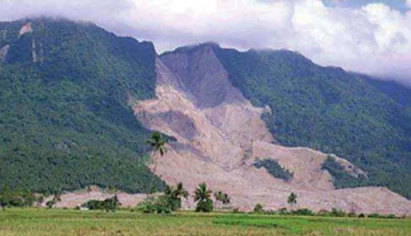
Baton Rouge sits on the eastern bluff of the Mississippi River, where the elevation drops sharply from about 20 meters to near sea level within a few blocks. This 20-meter escarpment, combined with the underlying Pleistocene terrace deposits and Holocene alluvial clays, creates natural conditions where slope failures can occur, especially after heavy rainfall events. We've worked on multiple developments along the bluff — from Perkins Road to the LSU campus — where a proper landslide assessment was critical before any excavation or foundation work. The soft, high-plasticity clays common to this area require careful evaluation of shear strength and pore pressure, which we approach through a combination of borehole sampling, field vane testing, and laboratory triaxial compression.
For Baton Rouge bluffs cut by alluvial clays, the critical slip surface often follows a thin silt seam at 6 to 10 meters depth.
Method and coverage
- Unconsolidated undrained triaxial tests (ASTM D2850) on clay layers
- Direct shear tests (ASTM D3080) on sand or silt seams
- Atterberg limits and natural moisture content
Regional considerations
ASCE 7-16 classifies Baton Rouge under seismic design category B, but the real risk here isn't the earthquake itself — it's the combination of low-strength clay soils and high groundwater. After heavy rain from a Gulf storm, pore pressures in the bluff can rise quickly, reducing effective stress along potential failure planes. We've seen shallow translational slides in fill slopes and rotational failures in natural cuts along the Comite River basin. A proper landslide assessment identifies these critical conditions before construction, allowing for drainage improvements or shear reinforcement early in the design phase.
Standards that apply
ASCE 7-16 (Minimum Design Loads and Associated Criteria for Buildings), ASTM D1586-18 (Standard Test Method for Standard Penetration Test), ASTM D3080-18 (Direct Shear Test of Soils Under Consolidated Drained Conditions), FHWA-NHI-05-089 (Slope Stability Reference Manual)
Associated technical services
Field Reconnaissance & Mapping
Surface inspection for cracks, scarps, and seepage. We map geology and land use to identify failure-prone zones.
Subsurface Exploration & Sampling
SPT borings, undisturbed tube sampling, and piezometer installation to characterize soil layers and groundwater.
Laboratory Strength Testing
Triaxial, direct shear, and Atterberg limits on intact samples to determine peak and residual shear parameters.
Stability Modeling & Report
Limit equilibrium analysis (Bishop, Spencer) under static and seismic conditions. Recommendations for drainage, retaining walls, or soil reinforcement.
Typical parameters
Common questions
How much does a landslide assessment cost in Baton Rouge?
For a typical residential or small commercial site, the cost ranges between US$980 and US$3.740 depending on the number of borings, lab tests, and complexity of the slope. Contact our team for a site-specific quote.
What is the main cause of landslides in Baton Rouge?
The primary cause is the combination of high-plasticity clay soils (CH) from Mississippi River alluvium and elevated groundwater after heavy rainfall. The natural bluffs along the river and the Comite River basin are particularly susceptible to shallow translational and rotational failures.
Do I need a landslide assessment for a small residential project on a flat lot?
If your lot is flat and not adjacent to a bluff or drainage channel, a full landslide assessment may not be required. However, if you are excavating a basement or building near a slope, local codes and prudent engineering practice recommend at least a geotechnical evaluation to rule out instability.